Motorway A99, 8-lane Expansion between Munich North and Haar
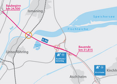
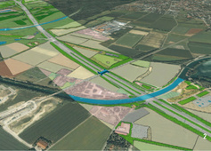
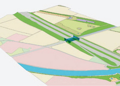
Motorway A99 is the motorway bypass of Munich. The traffic flows of five motorwayslead onto it and are directed around the city of Munich. The current traffic load is at150,00 vehicles/24 h. At the moment, A99 is a six-lane motorway and has a temporaryhard shoulder release since 2005. Despite this improvement, the existing carriagewaycross section cannot answer the average increase of traffic volume. Therefore, theAuthority of Motorways South Bavaria plans the eight-lane expansion of A99 on a lengthof 18.6 km between interchange Munich North and junction Haar. In addition to renewingbridges and the superstructure, projects in view of noise protection – lownoise surfaceand higher noise barriers – are planned.In collaboration with Prof. Schaller UmweltConsult GmbH (PSU), a partner company of theSS F Group, the integration of BIM and GIS engineering planning and environmental datais tested in practice.Future requirements of flawless mutual data exchange between engineers and environmentaldesigners are in focus in order to optimize and monitor all necessary environmentalaspects from the beginning of the planning to project implementation and completion.
Particularities
- Autodesk Revit as interactive BIM – CAD system for a completely continuous 3D planning
- 3D data collection of existing structure for demolition planning and construction within existing structures and with continued traffic
- cost estimate and cost calculation on the basis of models (volume, surface, attributes)
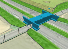
- better coordination with geotechnical experts by using of the 3D model
- essential structure plans are derived from the consistent 3D model
- the 4D model is created through linking the 3D model to the construction process
- individual construction phases with the required traffic management are clearly
demonstrated at the 3D model in view of coordination - simple transfer of quantities and areas of individual components
- simulation of the cost progression over time: 5D model, link of 4D model to components fabrication costs
- use of 3D model as basis for structural analysis
- outlook to the future: use for maintenance/operation/renovation – use of data in the programme SI B-Bauwerke, provision of models, integration into the GIS system used by the client